

Engineers, Land & Soil Surveyors
State of the art allied engineering works!
Meters boreholes drilled
SQ.KM.LAND SURVEYED
Projects completed
Kilometers corridor surveyed
Years experience
Services
We do not compromise on quality, Our finest services are guaranteed for you.

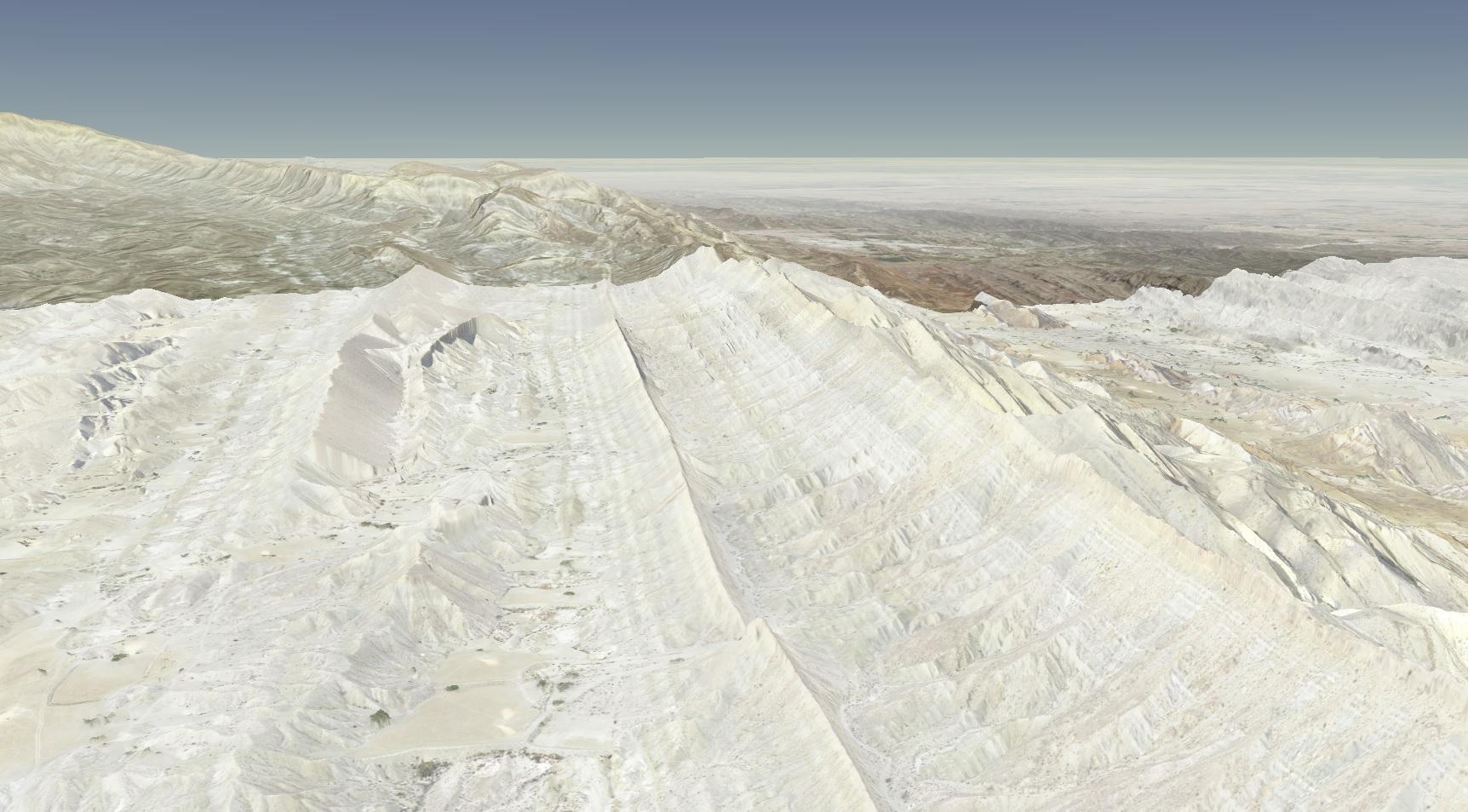
Aerial / Cadastral Surveys
We deal in complete drone mapping, inspection, and monitoring end to end solutions! Contact us for inquiries regarding your projects!
Aerial / Cadastral Surveys
We deal in complete drone mapping, inspection, and monitoring end to end solutions! Contact us for inquiries regarding your projects!
- Precision agriculture
- Utilities, pipelines & powerlines
- Oil & gas, wildlife & environment
- Mining, inspection and monitoring
- Construction
- Assets
- Surveying
- RGB
- Multispectral
- NDVI
- Thermal
- Multi-temporal surveys for change detection
- Volumetric estimations
- Corridor & linear mapping
- Emergency response mapping
- Digital surface models
- Digital orthophotos
- Calibrated radiometric orthophotos
- Photogrammetry
- Digital Terrain Models
- NDVI
- Thermal maps
- Video surveys

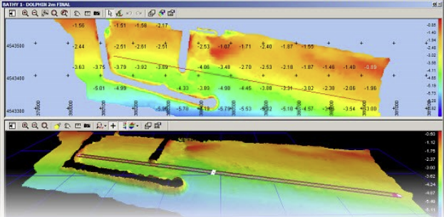
Hydrographic / Riverine Surveys
Need accurate Hydrographic or Riverine Survey done with SONAR? Contact us!
Hydrographic / Riverine Surveys
Need accurate Hydrographic or Riverine Survey done with SONAR? Contact us!
- Dams
- Rivers
- Lakes
- Canals
- Oceans

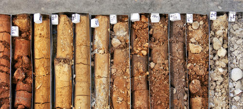
Geotechnical Investigations
Complete geo-technical studies using Rotary Drilling or other methods including Electrical Resistivity Survey and many more!
Geotechnical Investigations
Complete geo-technical studies using Rotary Drilling or other methods including Electrical Resistivity Survey and many more!

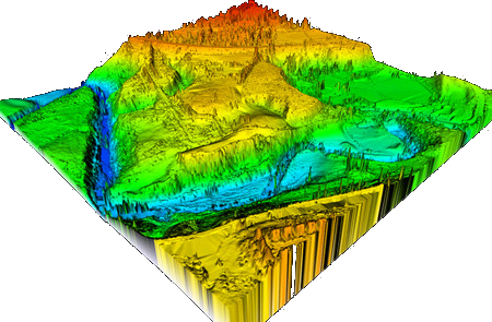
Topographic Surveys
The purpose of a Topographic Survey is to gather survey data about the natural and man-made features of the land, as well as its elevations.
Topographic Surveys
The purpose of a Topographic Survey is to gather survey data about the natural and man-made features of the land, as well as its elevations.

Traffic Surveys
Need 24, 48, 72 hours or more Traffic Counts at specific Locations? Contact us!
- Optional video recording
- Roadway volume counts
- Classification counts
- O-D survey
- Video recordings (up to 164 hours)
- and public opinion survey

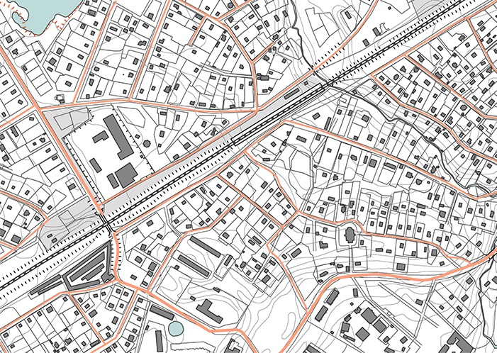
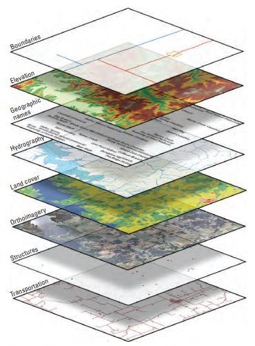
GIS Services / CAD Drawings
Computer Aided Drawings / GIS Databases are the most effective way to document technical drawings and related information in an organized manner!
GIS Services / CAD Drawings
Computer Aided Drawings / GIS Databases are the most effective way to document technical drawings and related information in an organized manner!
- Utility Mapping
- Route Network Analysis
- Digitization/Vectorization
- Water Resources Planning
- GCP Data Capture and analysis
- Topographical and Cadastral mapping
- Image GeoRectification / Georeferencing
- Rural/Urban:Planning,Development & Management

Satellite Image Processing
We deal in complete satellite imagery end to end solutions. Contact Us to inquire about our services!
Satellite Image Processing
We deal in complete satellite imagery end to end solutions. Contact Us to inquire about our services!
- Satellite Imagery Acquisition and Processing (Stereo, Mono)
- High-Resolution Imagery (Up to 30cm and more)
- GCP Installation and Processing
- Digital Elevation Model (DEM) Generation
- Digital Surface Model (DSM) Generation
- Normalized Digital Surface Model (nDSM) Generation
- Contouring
- Reservoir Volume Calculation
- Google Earth Engine Application Programming and Development


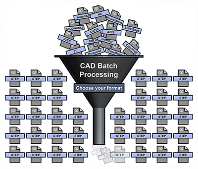
CAD Workflow Automation and Programming
CAD
Clients
Our professional clientele!


Testimonials
Our happy customers!
 One of the finest and technologically advanced surveying company which has taken over many national and international projects versatile nature, they have set altogether a standard in the said field and now strode towards new avenue of engineering and architectural consultancy. I am sure they’ll reach the summit of excellence in all their future endeavours.


Muhammad A
One of the best professional survey company in Pakistan.

Abdul Karim
Doing an excellent job in surveying & wishing them the best of luck for future endeavour.

Tanveer
Hafeez associates is providing surveying, soil investigation and structural engineering with a highly skilled team of professionals. My personal experience with these fellows is excellent.

Shahzad Mir
Skilled team of professionals in the field of land surveying and geo-tech engineering.

Asif Bajwa
Great Team and Great Commitments!!! un-conventional talented professionals with dynamic attitude to every problems. Keep it up my brothers.

Ali Usman Awan
GET IN TOUCH
we have a versatile experience of over 30 years!
Contact Us
Contact us to discuss your project!